Wednesday, 30 May 2012

Snowmelt tails away


The hydrograph above shows one rain-on-snow peak on 16 May, followed by mostly dry fine weather when you can clearly see the daily snowmelt pattern. You will also see that the water level is on a downward trend through the second half of May, with the daily melt wave-pattern becoming smaller and smaller. This tells us that the snowpack is disappearing quickly.

30 May, stage = 54cm, snowmelt season nearly over

Friday, 11 May 2012

Peak snowmelt

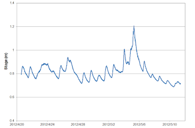
11 May, stage = 71cm. Is peak snowmelt over?


End of April to early May usually brings the peak snowmelt. This year is no exception. See the clear sine-wave pattern in the hydrograph that reflects the same pattern in daily air temperatures which are driving the snowmelt. April 28 to May 2 is a period of fine dry weather with only snowmelt driving the streamflow, but the next three days are influenced by rainfall which causes the largest peak on May 5, a typical rain-on-snow flood event.

Snow has now melted off from the lower elevations, and so the fine weather snowmelt pattern is likely to slowly fade out over the next couple of weeks as the snowline retreats up into the mountains.